

Public-Record Analysis | Public Services & Infrastructure
TxDOT Seeks Public Input on 606 Miles of US 83 Before December 19 Deadline
Residents can identify safety concerns, traffic problems and roadway needs along the highway from Carrizo Springs to the Oklahoma state line. The study is a planning effort, not a construction authorization.
AUSTIN, Texas — Texans who travel US Highway 83 have until December 19, 2026, to identify roadway problems and suggest improvements as the Texas Department of Transportation develops a long-range plan for approximately 606 miles of the highway.
The US 83 Texas Corridor Study extends from Carrizo Springs north to the Texas–Oklahoma state line. TxDOT is asking residents, motorists, businesses and other highway users to share their experiences through an online survey and interactive map.
The agency’s November 4 announcement says the study will consider existing roadway conditions, traffic operations, safety concerns and anticipated growth. It expects to complete the study in late 2027.
For highway users, the immediate opportunity is to identify needs while TxDOT develops its planning priorities. Submitting a concern does not guarantee a project will be recommended, funded or built.
How to participate
Public comments are due December 19, 2026.
TxDOT’s study page links to the participation tools and asks users to describe how and when they use US 83, along with their concerns, issues and priorities.
Useful information can include a location, the nature of a problem, when it occurs and how it affects travel. Examples include difficult intersections, congestion, pavement concerns, freight access, bicycle and pedestrian connections, and gaps between communities and other transportation routes.
Those examples reflect the kinds of corridor needs TxDOT is evaluating; they are not a verified list of the survey’s menu choices. Follow the participation platform’s on-screen instructions when submitting information.
What the study covers
TxDOT describes the corridor as crossing 22 counties, six agency districts, nine metropolitan planning organizations or councils of governments, and 23 cities.
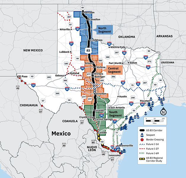
The agency has divided it into three planning segments:
- South: US 277 in Carrizo Springs to the Kerr–Kimble county line.
- Central: The Kerr–Kimble county line to the Stonewall–King county line.
- North: The Stonewall–King county line to the Texas–Oklahoma state line.
The study page identifies safety, operations, freight movement, asset condition, connectivity, multimodal access, economic resilience, and environmental and community context among its considerations.
The segments provide a framework for examining conditions along a highway that connects rural communities, regional centers and other major transportation routes.
Why the official map extends farther south
TxDOT’s overview map also depicts US 83 toward the Texas–Mexico border and identifies a separate, previously studied southern corridor.
That should not be confused with the current study’s stated limits: Carrizo Springs to the Oklahoma state line.
TxDOT says the present effort will build on work and improvements identified in the US 83 Regional Corridor Study, completed in 2023, as well as the ongoing I-27 System in Texas Implementation Plan.
The map therefore provides context beyond the present study area. It is not a construction schematic or a final property-acquisition map.
What happens after comments close
TxDOT anticipates four rounds of stakeholder engagement from winter 2026 through summer 2027.
Its described process includes reviewing existing conditions and needs, developing and prioritizing strategies, selecting improvement strategies and preparing an implementation plan. The agency’s late-2027 completion date is an expectation, not a guaranteed deadline.
The materials inspected for this report describe corridor planning. They do not announce a funded construction project, final engineering approval or authorization to acquire particular properties.
Potential improvements would require further project-specific decisions. A study recommendation should not be treated as proof that construction will occur or that its funding and approvals are complete.
Why this matters
US 83 serves communities spread across a substantial part of Texas. TxDOT identifies it as an important route for rural connectivity and the movement of freight and people.
Location-specific public input can give planners information about conditions highway users encounter: where delays recur, which connections are difficult and what makes a location feel unsafe. Those observations are public input to be evaluated, not independently established engineering findings.
The next checkpoints are the December 19 comment deadline, subsequent stakeholder engagement and the study’s eventual recommendations. Texans wishing to contribute should use the participation tools linked by TxDOT before the current comment period closes.
Sources
TxDOT — survey and interactive map, linked by the official study page.
Verified through November 5, 2026.
Access note: TxDOT’s study page, news release and original overview map were inspected. The participation platform could not be independently opened during this review. Its link and comment deadline are confirmed by TxDOT’s official study page; no survey submission or interface test is claimed.
EDITORIAL NOTICE: This report reflects records and information available at publication. Allegations, charges, and disputed claims are not findings of wrongdoing. Submit documented correction or clarification requests to The Texas Public Record. Material errors will be corrected transparently.
The Texas Public Record
Rights. Accountability. Awareness.
The record doesn’t blink. Keep your eyes on Texas.